A Sensible
Distortion:
Gerard Mercator's
Innovative Maps
Allowed Mariners
To Set a Course
On Flat Surfaces.
Christopher Columbus and the Great Age of Discovery
HIST 351 ~ Fall 2010
“We all know Gerard Mercator’s name,
but probably not one in a million of us
knows anything else about the man
who revolutionized mankind’s view of our planet.”
— Jan Morris
By Ronald Fritze
December 2, 2010
Based on personal experience, I can attest to the accuracy of Jan Morris’s observation. In school we all learn something about maps, even though the teaching of geography in the United States has been grievously neglected. One of the things we are told is that most world maps are based on a something called a Mercator projection. But generally we are not told what a Mercator is.
My first impression during elementary school was that it was some science term. Later I found out that it was the inventor’s name. At that point I assumed Mercator was a relatively modern person, possibly of eighteenth-century vintage but more likely a nineteenth-century man. So I was surprised to learn that Mercator was a man of the sixteenth century. As we will see, it makes perfectly good sense given the historical context.
We Begin with the Sphere.
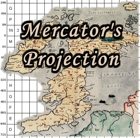
The first thing we need to understand is why the Mercator projection is important. Everyone in modern technological societies is taught that the earth is a sphere. One of the main purposes of maps is to provide a picture of what the surface of the earth actually looks like in a graphic and somewhat abstract manner. One of the things we should learn in school is how to read the abstract language and symbols of maps. But there are other problems regarding the making of maps. One is related to the spherical nature of the earth. The most accurate map of the earth is a globe, but globes can be hard to use for navigation or purposes of detailed study. They are also hard to construct, and unless they are made so large to be impractical, they cannot depict enough detail to be useful for most purposes.
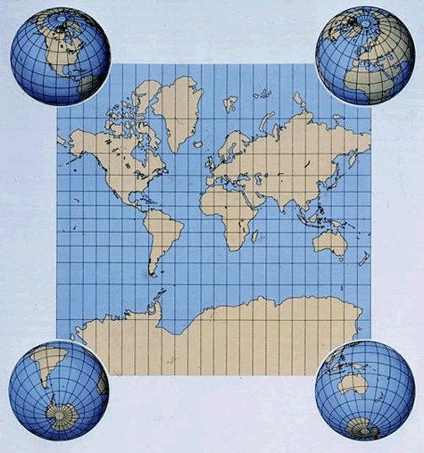 Flat maps are easier to use but they have problems as well. A flat world map attempts to depict on a flat surface the geographical features of a sphere. That creates distortions. These distortions are not a problem on small scale maps or on maps that are in the lower latitudes approaching the equator. Distortion is a big problem in polar regions where a degree of longitude shrinks down to nothing at the poles.
Ptolemy Recognized the Problem
But Didn't Solve It.
Claudius Ptolemy in the second century recognized the problem of mapping a spherical surface. He was very concerned to measure and map accurately the geography of his world but did not find a solution to the representational disparity between sphere and a flat surface. For the most part, Ptolemy’s conceptual difficulties were grounded in theory because his world focused on the Mediterranean Sea where the problems of distortion were not that great.
After 1492, the limited world of European consciousness became greatly expanded. Thirty years later the earth had been circumnavigated and Europeans were sailing into the polar regions seeking Northwest and Northeast Passages. Various people produced flat maps, but they proved to be useless for high seas navigation. Distortions due to the sphericity of the earth meant that a straight-line course on a flat map did not equate to a straight line on the spherical surface of the earth.
The purpose of Mercator’s projection was to depict the earth on a flat surface in a manner that allows a true course over the surface to be traced in a straight line. To achieve that goal, Mercator had to introduce certain significant distortions in the appearance of the earth. Keep in mind, the entire top and bottom of a Mercator projection is really one point, either the North or the South Pole. Instead, it stretches out the entire length of the map. As a result, Europe appears quite large in relation to other regions of the map, while the northern part of North America, Greenland, Scandinavia, and Siberia appear much larger than they actually are. The distortion in the Southern Hemisphere is less evident because the land mass in the upper levels of latitude in that hemisphere is much less extensive.
In our time, people have accused the Mercator projection of being Eurocentric because its depiction of Europe renders it as relatively larger than it really is. The accusation against Mercator, however, is anachronistic. If he was Eurocentric, it was because Europe was his world, and his maps were designed for use by Europeans. Mercator was not only a cartographer. He was also a businessman who needed to sell maps. If the Chinese had contacted him to make maps for them, he’d have gladly provided them with a Sinocentric map using his projection.
Luckily for Gerard, de Cremer the Cobbler
Had a Brother Who Believed in Education.
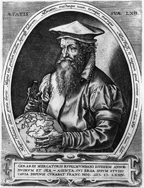
Who was Gerard Mercator (1512-1594)? Mercator is a Latinization of the family name Cremer — a change that follows the common practice among scholars of the early modern era to Latinize their names. His father was Hubert de Cremer, a cobbler who struggled to support his wife and five children. In 1512, the impoverished Hubert moved from Gangelt in Julich, Germany, back to his family’s hometown of Rupelmonde on the Scheldt River near Antwerp in what is now Belgium.
Born into poverty, the young Gerard was fortunate that his uncle, the cleric Gisbert de Cremer, took charge of his education. Gerard was a bright and hardworking student, helping him to win a place at the highly respected University of Louvain. Louvain was also a bastion of the defense of Roman Catholic orthodoxy, and although it appears that Mercator’s sympathies lay with the Reformers, he was not outspoken about it.
Despite his circumspect and cautious nature, Mercator did not escape the intense religious turmoil of his time. In 1543 the Inquisition investigated Mercator and placed him in the dungeons of Rupelmonde Castle while it sought evidence of heresy. But powerful and persistent friends and his own caution saved Mercator from death. As we know, others were not so lucky.
Later, Mercator moved to Duisburg in Germany where there was greater religious toleration in the lands of Cleves Julich. Not one to take a strong stand, Mercator did business with both sides of the religious divide created by the Reformation.
While Mercator was a student at Louvain, he had the opportunity to study with the cosmographer Gemma Frisius, who would introduce Mercator to the art of mapmaking, particularly the
 construction of globes. Mercator assisted Gemma and the goldsmith Gaspard van der Heyden in the construction of a globe for the Emperor Charles V in 1535. It appears that the study of philosophy was Mercator’s first love, but thanks to Gemma, he came to realize that cartography could put food on the table.
Putting food on the table became a more immediate issue when Mercator married Barbe Schellekens in 1536. The couple rapidly increased their family by six children, three boys and three girls.
An Early Form of Christian Publishing.
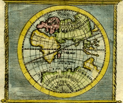
In 1537, Mercator published his first commercial map, a depiction of the Holy Land — a subject with prospects for good sales. It did not disappoint and helped solidify Mercator’s career path. Next he turned in 1538 to the composition of his first world map. It consisted of two heart-shaped projections of the northern and the southern hemispheres. While an accurate piece of cartography, its presentation obscured as much as it revealed.
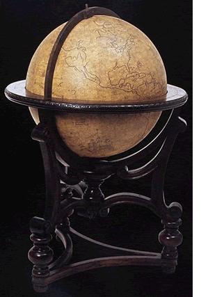
Mercator’s next big project was the production of his own globe of the world. It appeared in 1541. Keep in mind, while a sheet map could be mass produced on a printing press, only the gores or the map part of a globe could be mass produced. The frame of the globe and its stand had to be individually handcrafted. So globes were expensive. Mercator’s globe was a fine piece of both cartography and craftsmanship. He sold his globes as fast as his shop could make them, and the globe continued to sell throughout his lifetime. Mercator’s globe was a source of the most current geographical knowledge and was also quite decorative as well. The globe made his reputation in sixteenth-century Europe.
Thanks to his growing reputation as a cartographer, Mercator attracted the attention and friendship of other greats or future greats of sixteenth-century mapmaking and geographical study. The young English scholar John Dee arrived to study at Louvain in 1547. He and Mercator became lifelong friends and colleagues. Later, Dee would rise high in the geographical councils of Queen Elizabeth I of England and would bring Mercator’s talents to the attention of her government.
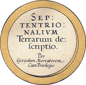
Another colleague and business partner was the printer Christopher Plantin. Mercator also became friends with Abraham Ortelius during the 1540s. Ortelius published Mercator’s famous Theatrum Orbis Terrarum in 1570. The first modern atlas, it sold very well when it came out.
Meanwhile, Mercator grappled with the problem of constructing a useful flat map. His solution was to draw the lines of longitude as straight lines and elongate the lines of latitude the further north they were. This technique made it possible to plot a straight line course on his map that resulted in a straight line course at sea.
It Looks Impressive in the Study,
but How Can I Make It Work at Sea?
Mercator published his world map in 1569. The problem is that Mercator’s world map was a scholarly work with notes in Latin, failing to address the practical concerns of sailors. Furthermore, the calculations needed to make the map useful for navigation were cumbersome. The map did not go over well with the conservative seafarers of his day.
Mercator never tried to explain the theory behind his map. As a result, for its first three decades, the map decorated the walls of the studies of scholars and statesmen and not the navigation tables of mariners.
The task to transform Mercator’s creation into a practical tool was fulfilled by the English mathematician Edward Wright in his Certain Errors in Navigation Detected and Corrected of 1599. Wright provided mathematical tables for Mercator’s map, making it much easier to use for navigation as sea. Mercator’s failure to deal with the theoretical aspects of his projection actually caused some English scholars of the eighteenth century to assert that Wright should be given credit for the discovery of the projection, not Mercator.
Mercator quickly lost interest in his new projection. From his point of view, he wanted his legacy to be the writing of a compendium of the state of geographical and historical knowledge in his time. Another project important to him was the composition of maps illustrating Ptolemy’s Geography, the old favorite from the second century. That work appeared in 1578.
His Last Work Was a Three-Volume Atlas.
Age, infirmity, and death prevented Mercator from finishing his great project, the compendium, but he did manage to publish a three-volume atlas (1585, 1589, and 1595) that superseded Ortelius’s Theatarum as the premier atlas in Europe. Mercator’s maps were strikingly original, while Ortelius borrowed heavily from other scholars’ maps. Since his maps were his originals, Mercator could compose them according to a consistent format and a uniform approach. Unfortunately Mercator did not live to see the third volume of his great atlas appear in print. That volume was completed by his son Rumold.
If someone had asked Mercator what he considered to be his greatest accomplishments, he would have emphasized his globe, his atlas, and his work on Ptolemy. His contemporaries probably would have said the same thing. It was only later when the Mercator projection gained widespread acceptance that it came to be considered the pioneer cartographer’s greatest achievement — and in retrospect, it was. Only antiquaries, map collectors, and historians of cartography are interested in the rest of his work. The Mercator projection has stood the test of time. All else that Mercator did has been superseded.
Christopher Columbus and the Great Age of Discovery
HIST 351 ~ Fall 2010
Christopher Columbus and the Age of Discovery
is an internet learning resource directed by Dr. Ronald Fritze,
Dean of the College of Arts and Sciences
at Athens State University in Athens, Alabama.
The Age of Discovery web project
is part of the CornDancer family
of open-access, non-commercial, developmental websites.
|